• Skip to main content
itrc_logo

EDM

Home
Interactive Directory
Introduction and Overview
Introduction
Overview of Guidance Document
Data Management Planning
Data Management Planning Home
Data Management Planning Overview
Data Governance
Data Lifecycle
Data Access, Sharing, and Security
Data Storage, Documentation, and Discovery
Data Disaster Recovery
Data Quality
Data Quality Home
Data Quality Overview 
Analytical Data Quality Review: Verification, Validation, and Usability
Using Data Quality Dimensions to Assess and Manage Data Quality
Considerations for Choosing an Analytical Laboratory 
Active Quality Control During Screening-level Assessments
Field Data Collection
Field Data Collection Home
Introduction to and Overview of Field Data Collection Best Practices
Defining Field Data Categories and Collection Methods
Field Data Collection Process Development Considerations
Field Data Collection Quality Assurance and Quality Control (QA/QC)
Field Data Collection Training Best Practices
Field Data Collection Training Best Practices Training Development Checklist
Other Considerations for Field Data Collection
Data Exchange
Data Exchange Home
Data Exchange Overview
Valid Values
Electronic Data Deliverables and Data Exchange
Data Migration Best Practices
Traditional Ecological Knowledge
Traditional Ecological Knowledge Home
What is Traditional Ecological Knowledge?
Acquiring Traditional Ecological Knowledge Data
Using and Consuming Traditional Ecological Knowledge Data
Managing Traditional Ecological Knowledge Data
Geospatial Data
Geospatial Data Home
Overview of Best Practices for Management of Environmental Geospatial Data
Organizational Standards for Management of Geospatial Data
Geospatial Data Standards
Geospatial Data: GIS Hardware
Geospatial Metadata
Geospatial Data Software
Geospatial Data Collection Consistency
Geospatial Data Field Hardware
Geospatial Data Dissemination: Web Format
Geospatial Visualization of Environmental Data
Public Communications
Public Communications Home
Public Communication and Stakeholder Engagement
Environmental Data Management Systems
Environmental Data Management Systems Home
Environmental Data Management Systems
Case Studies
Case Studies Home
Historical Data Migration Case Study: Filling Minnesota’s Superfund Groundwater Data Accessibility Gap
Case Study: USGS Challenges with secondary use of multi-source water quality monitoring data
LEK Case Study: Collection and Application of Local Ecological Knowledge to Local Environmental Management in Duluth, Minnesota
TEK Case Study: Improving Coastal Resilience in Point Hope, Alaska
Case Study: Integration of Traditional Ecological Knowledge to the Remediation of Abandoned Uranium Sites
Case Study: Local Ecological Knowledge of Historic Anthrax in a Natural Gas Field
Rest in Peace? A Cautionary Tale of Failure to Consult with an Indigenous Community
Case Study: Use of Traditional Ecological Knowledge to Support Revegetation at a Former Uranium Mill Site
Additional Information
Supplemental Resources
References
Acronyms
Glossary
Acknowledgments
Team Contacts
Navigating this Website
Document Feedback


Environmental Data Management (EDM) Best Practices
HOME

Case Study: Local Ecological Knowledge of Historic Anthrax in a Natural Gas Field

1 INTRODUCTION

This case study provides an example where local ecological knowledge (LEK) data were acquired and managed appropriately to provide insight into events that affect land-use planning.

The Pinedale gas field (PGF) is a major gas field in western Wyoming. The PGF was discovered in 1955 and produces 568 billion cubic feet of natural gas per year (U.S. Energy Information Administration 2015). The PGF ranks eighth in the United States for natural gas production. 

Past natural disasters, such as an anthrax outbreak, can have an adverse effect on production from the field and also post a local health risk if the burial site or sites are disturbed. This case study shows how local ecological knowledge helped avoid potential exposure to anthrax when drilling new oil and gas wells in a location where anthrax-infected animals were buried.

2 BACKGROUND

Anthrax is a spore from the bacterium Bacillus anthracis. These spores can persist in the environment for up to 50 years in the soil and up to 200 years in the bones of animals that have died from anthrax (Skirrow 2019). This persistence of anthrax spores in the environment presents a natural-disaster risk to agriculture and local economies. For example, the U.S. Department of Agriculture, Farm Service Agency (USDA-FSA) states that a ranch can receive up to 75% of the fair market value of any animal lost due to a natural disaster (USDA-FSA 2021). To put it another way, a rancher stands to lose 25% of their expected profits following a natural disaster if they are eligible at all given that natural disaster relief is not available if the adjusted gross income is greater than $900,000. 

In this context, any LEK that the landowners/ranchers can gather on known or suspected hazards, such as a burial area of anthrax-infected animals, will help to limit the health and economic risks to their operation and livelihood.

3 TRADITIONAL ECOLOGICAL KNOWLEDGE INPUT

In August 2008 one of the gas companies operating in the PGF started staking locations to drill new wells. A concerned rancher with historic knowledge of the Pinedale area contacted the Wyoming Department of Environmental Quality (WYDEQ) to share that the company had staked two wells on anthrax burial sites from an outbreak in the 1950s. The rancher sent the WYDEQ the coordinates of the burial sites.

Using the information from the rancher, the WYDEQ used mapping software in a geographic information system to plot the points with both 100- and 200-meter buffers, added the State Engineers Office permitted wells in the area (also buffered by 200 meters), and added the streams to the map to show the water downstream from the burial sites. Figure 1, which was the result of this effort, shows the water wells and oil and gas wells in proximity to the two anthrax burial locations.

Figure 1. Current drinking water well and oil and gas well locations relative to two historical anthrax burial sites from the 1950s.
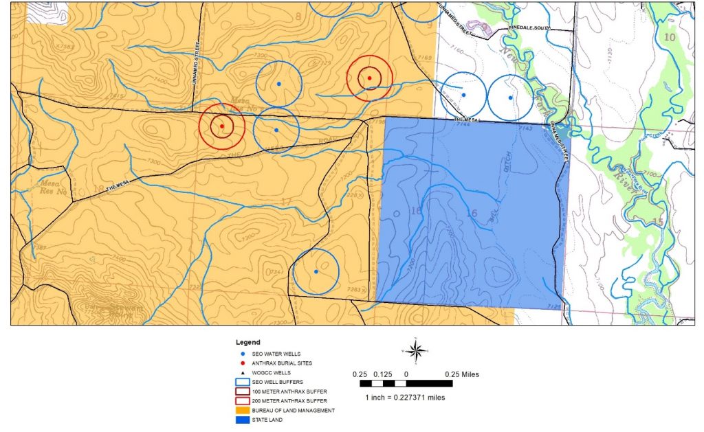
Source: C. Kopplin, Used with permission.

4 END PRODUCT

The map of the anthrax burial sites was exported, and the jpg file was sent to the Wyoming Department of Agriculture (WDA). The WDA then worked to have the areas fenced off and posted signs that any work in the given areas had to get prior approval from the WDA. The results of this project will help prevent anthrax from contaminating the downstream water supply that people count on for drinking water, watering livestock, and irrigating fields.

5 REFERENCES AND ACRONYMS

The references cited in this fact sheet, and the other ITRC EDM Best Practices fact sheets, are included in one combined list that is available on the ITRC web site. The combined acronyms list is also available on the ITRC web site.

image_pdfPrint this page/section


EDM

Home
glossaryGlossary
referencesReferences
acronymsAcronyms
ITRC
Contact Us
About ITRC
Visit ITRC
social media iconsClick here to visit ITRC on FacebookClick here to visit ITRC on TwitterClick here to visit ITRC on LinkedInITRC on Social Media
about_itrc
Permission is granted to refer to or quote from this publication with the customary acknowledgment of the source (see suggested citation and disclaimer). This web site is owned by ITRC • 1250 H Street, NW • Suite 850 • Washington, DC 20005 • (202) 266-4933 • Email: [email protected] • Terms of Service, Privacy Policy, and Usage Policy ITRC is sponsored by the Environmental Council of the States.